Geography
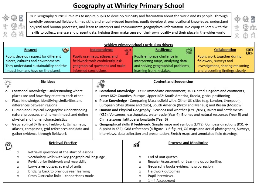
Intent
At Whirley, we aim to deliver a high-quality curriculum which inspires our children to want to be young geographers, developing their understanding of places and environments and the importance of sustainable development for the future of our world. We want them to develop a fascination and respect for our world and its people.
We passionately believe fieldwork is a vital ingredient of teaching Geography and we use Macclesfield, its surrounding areas and other areas of the North West of England as a vital resource. Fieldwork studies are embedded into each year groups curriculum.
Our curriculum is designed to enable our children to:
- Learn about Whirley and its surrounding environment, comparing their life with other regions of the United Kingdom and the rest of the world.
- To recognise the physical and human characteristics of each area and how these provide a geographical context for understanding the actions of processes.
- Learn how to draw and interpret maps and develop the skills of research, investigation, analysis and problem-solving.
- Communicate geographical information in a variety of ways, including through maps, photographs tables, charts, diagrams and writing.
Reception
In Reception we build on knowledge gained in pre-school settings and home environments. We begin to discuss and recognise features of our immediate environment, such as our classroom, playground and homes. As an introduction to mapping out features of our environment, through play we begin to use positional language and plot the key features of our playground and classroom using Lego. During this, the children are encouraged to share opinions and points of view on elements of the playground and classroom. Building upon their physical exploration, children are introduced to simple maps and photographs of an area they have explored during Welly Walks and through a visit to Bewilderwood.
Year 1
Building upon the learning in EYFS, the children continue their Geographical journey by talking about the country we live in, what it is called and recognising Macclesfield’s position within the UK. Children are introduced to the language of ‘The United Kingdom’ and how it is made up of 4 countries and their position relative to each other.
Following the learning though play approach in Reception, Year 1 children have a look at our school’s outdoor environment and begin to draw a simple map using appropriate symbols. In terms of fieldwork, children take a local walk in the local environment to post the post cards that they have written in our English lessons and then draw a map of this walk.
Building upon the prior learning of the reception Welly Walks, children are introduced to the language of ‘physical’ and ‘human’ geography of the Whirley school grounds. Children go outdoors to identify the physical and human Geography of our school grounds. Moving on from this, the children compare our school grounds to a different school in Macclesfield and its different environment.
Throughout the year, the Year 1 children identify the seasonal and daily weather patterns of the United Kingdom and have a go at measuring the rainfall levels at Whirley. Moving on from this, children compare the temperature and rainfall with other locations outside of the United Kingdom.
Year 2
The children build on their learning in Year 1 by initially revising countries of the U.K (whilst additionally learning about their flags), before specifically learning about the four capital cities. The children also spend time learning about famous landmarks within these cities (human and physical) and they make comparisons between London and their home town Macclesfield.
To help give the children a base for their learning in Year 4, they learn four of the UK’s prominent rivers and gain an early knowledge of which surrounding sea they flow into. A simple profile of a major river is carried out, giving the children the opportunity to carry out research, supporting the computing curriculum. They are introduced to the name and location of the River Bollin and make connections between this river and the Irish Sea.
Links are then made with the five oceans of the world and the seven continents. They learn that the UK is part of Europe. As well as learning their names and locations, the children learn some basic facts about each continent. This helps support work in Science as they begin to learn about habitats.
Building on work in Year 1, the children study Whirley’s surrounding environment, with a particular focus on Bodmin Park. This gives the children the opportunity to further study prominent physical and human features; studying the types of housing in their local environment and the road network. This supports work in History as they study how both have changed since the Victorian period. This lays a foundation for local studies in Year 6.
A field study of Bodmin Park also allows for development in map work. A broader range of symbols are used, preparing the children to use standard symbols in Year 3. They are introduced to the four basic compass points during field studies.
Year 3
Building on their previous learning, children revise the names of the countries and capitals of the UK, before learning about the counties and cities that are closest to Macclesfield. In particular, children spend time comparing the size and population of Cheshire East / West, Greater Manchester and Merseyside and the cities within them.
This leads onto the children being introduced to ordnance surveys. Links are made to Macclesfield and Whirley Primary School. Further links are then made as they start looking at the town centre and identifying the main features, whilst making comparisons with Liverpool. There is an opportunity to build on their work in Year 2, in relation to the Irish Sea.
Using grid references, the children move on to looking at Macclesfield Forest on an ordnance survey map. Children recognise that the OS map shows buildings differently and that it has lines on it. Contour lines are explored and referred to when discussing the OS maps. Using the map of Macclesfield Forest, we discuss the footpaths/streams and rivers and reservoir, learning how we know what these are on a map. The children are helped to recognise the topographical features on maps, specifically focusing on Teggs Nose, Beeston Crag and the Cheshire Plain.
Building upon their previous study of the school grounds and local environment, the children create a map of a local walk, stopping at key points to record what they can see using 4 compass points. The children go on to plot a journey using a journey stick with a compass.
Year 4
In Year 4, children describe and understand key aspects of physical geography, including volcanoes, earthquakes, the water cycle, rivers and reservoirs (building on from a basic introduction to rivers in Year 2).
The children carry out fieldwork at Quarry Bank Mill and identify the river features learnt in the class room and in real life, as well as learning additional information regarding the area. During this visit, the children develop their map skills by locating features on a range of maps, creating and following routes to get from one point to another and drawing a sketch map from a high view point.
Whilst visiting Quarry Bank Mill the children locate and note key topographical features of the area and compare with the area of Macclesfield in which Whirley is located, to supplement their studies in Year 3.
Children build on their 4 figure compass knowledge from Year 2 and 3 and will begin to use 8 figure compass points to identify features on a map. Whilst on the trip, children also gain a more in depth knowledge of the physical features of the River Bollin. The children present their findings in excel tables and graphs.
In human geography the children learn about the River Bollin’s importance in relation to settlements and its impact on the industrial revolution and in particular Macclesfield’s silk industry.
Developing their understanding of continents of the world and capital cities, the children focus on Europe, specifically Rome. Italy (and its relative position to Mount Vesuvius) and Oslo, Norway. Comparisons are made between the two cities themselves and with Macclesfield.
Year 5
To build on their previous learning about countries within Europe, children in Year 5 gain a deeper knowledge of continents around the world focusing on South America; also focusing on the location of significant countries and names of capital cities within this region.
Following on from this, children compare similarities and differences through a physical and human study comparing features of their home town (Macclesfield) to different areas of South America. This study includes: biomes, natural resources, landscapes (tropical/desert), types of settlement, land use, temperatures, rainfall and economic activity. Children will have the opportunity to visit Macclesfield where they will be able to compare the physical features of where they live with specific areas of the Amazon rainforest.
A study of time zones including day and night supports their learning in Science when they study Earth and Space.
Through the year key skills are taught; children develop their ability to use an atlas (particularly when studying South America), they embed their learning of 8 figure compass points and they begin to use 6 figure grid references, having learned to use four the previous year.
Year 6
In Year 6 the children carry out a significant study of Macclesfield, bringing together much of the knowledge of they have acquired in previous studies of their local environment. A number of field trips will take place through the year both around school and in the centre of Macclesfield; giving the children the opportunity to use OS maps of Macclesfield, six figure co-ordinates, interview local residents and carry out a range of surveys, both close to school and in the town centre. The study of Macclesfield is also part of Year 6 History studies (See History Rationale).
Building on from studies in previous year groups, where the children have studied specific localities, countries and continents, an even greater use of atlases is made to study the world as a whole. This allows the children to learn about the position and significance of latitude, longitude, Equator, Northern Hemisphere, Southern Hemisphere, the Tropics of Cancer and Capricorn, Arctic and Antarctic Circle. During this study a greater understanding of time zones is developed using the line of Meridian/GMT. At this time the children carry out a short case study of Russia and Moscow specifically (making a connection with their study of World War II in History) . The children develop their knowledge of latitude, longitude when comparing the position of Moscow and London.
Assessment in Geography
When creating the short-term plans for the teaching and learning, essential knowledge, as cited on the curriculum maps, is referenced and retrieval practices implemented – to know more and to remember more.
Over the period of study the children will be encouraged to ‘bridge back’ retrieving their prior learning and over time, being able to explain links and develop a deeper understanding of the geography learned across key stages.
At the end of a unit of study the children are tasked with completing a low stakes quiz – these may be multiple choice or short answers. These quizzes will be revisited later to ensure retention is true. The scores will determine whether the child has been able to know more and remember more.